© 2021 Oriental Institute, The Czech Academy of Sciences
Web design by Nyx Alexander Design ®
CHRISTIAN
DESTROYED
MONUMENTS
ISLAMIC
PROFANE
2
40
3

13
COMPLETELY
RAZED
32
RUINED
45


Basic definitions of monuments given
at individual entries are based on a
comprehensive catalog of Mosulʼs
destroyed sites that is published in the
project teamʼs book Mosul after Islamic
State: The Quest for Lost Architectural
Heritage (Palgrave Macmillan 2021).


state
period
religion
location
code
name

Al-Tahira Syriac Orthodox Church (al-Tahira al-Kharijiya)

UNKOWN
ORIGIN;
OTTOMAN
English War Cemetery

Great Mosque of al-Nuri and Minaret al-Hadbaʼ

Shrine of Imam Yahya ibn al-Qasim – Madrasa al-Badriya
Shrine of Imam ‛Awn al-Din Ibn al-Hasan


Mosque of al-Khidr (al-Jami‛ al-Ahmar, al-Jami‛ al-Mujahidi)
Mosque and Tomb of Nabi Yunus (Prophet Jonah)
Mosque and Tomb of Nabi Jirjis (Prophet George)
Mosque and Tomb of Shaykh Qadib al-Ban
Mosque of Hamu al-Qadu – Tomb of ‛Alaʼ al-Din


Mosque of Nabi Shith (Prophet Seth)
Shatt al-Jumi Mosque – Tomb of Shaykh Ibrahim
al-Naqshbandi
Tomb of Ibn al-Athir (Qabr al-Bint)
Mosque and Shrine of Imam Ibrahim
Mosque and Tomb of Shaykh Fathi
Mosque of Shaykh Abu al-‛Alaʼ
Mosque and Tomb of Nabi Daniyal (Prophet Daniel)
Shi‛i Mosque and Husayniya Rawdat al-Wadi
Takiya and Tomb of Muhammad al-Afghani (Shaykh al-Shatt)
Shrine of Imam ‛Ali al-Asghar
Mosque of Sultan Uways and adjacent cemetery
Shrine of Imam ‛Abd al-Rahman – Madrasa al-‛Izziya
Shrine and Mosque of Imam al-Bahir
Shrine of Imam ‛Ali al-Hadi
Mosque and Shrine of Imam Muhsin – Madrasa al-Nuriya
Mosque and Tomb of ‛Isa Dadah and adjacent cemetery
Mosque and Tomb of Shaykh ‛Ajil al-Yawar
Mosque and Madrasa of al-Ridwani
Hammam al-Saray Mosque and Shrine of al-Sitt Nafisa
Mosque and Tomb of Shaykh Muhammad al-Abariqi
Mosque and Shrine of al-‛Abbas
Mosque and Tomb of Imam Zayd ibn ‛Ali
Cemetery adjacent to the Mosque and Tomb of Umm al-Tis‛a
Madrasa of the ‛Abdal Mosque
Tomb of Shaykh Mansur
Tomb of Abu al-Hawawin / Shaykh
‛Amir
Mosque and Shrine of Awlad (or Banat) al-Hasan
– Mosque of Bayt Shahidu
Mosque of Imam Muhammad / Mosque of al-Sab‛awi
Tomb of Shaykh Rashid Lolan
Shrine of Imams Hamid and Mahmud
Hammam al-ʽUmariya
Tomb of Shaykh Ibrahim
Mosque of Mahmud ibn ʽAbd al-Jalil al-Khidri
Al-Saray Police Station / Madrasat al-Sanaʼiʽ
C14
C27
I02
I03
I04
I05
I06
I07
I08
I10
I11
I12
I14
I15
I16
I18
I19
I21
I22
I28
I29
I34
I35
I36
I37
I44
I47
I48
I50
I51
I54
I55
I57
I58
I61
I62
I63
I64
I67
I68
I69
I70
I71
I73
P16
Mosque and Tomb of al-Kharrazi
I74


map
model
MODERN
ATABEG
ATABEG
ATABEG
ATABEG
SINCE THE
ASSYRIAN
PERIOD
UNKOWN
ORIGIN;
OTTOMAN
ATABEG
ORIGIN;
OTTOMAN
OTTOMAN
OTTOMAN
MODERN
MODERN
ATABEG
UNKOWN
ORIGIN;
OTTOMAN
OTTOMAN
OTTOMAN
OTTOMAN
UNKOWN
ORIGIN;
ILKHANID
OTTOMAN
ATABEG
ATABEG;
OTTOMAN
MONGOL;
OTTOMAN
ATABEG
ATABEG
MODERN
OTTOMAN
ATABEG (?)
MONGOL (?)
OTTOMAN
OTTOMAN
OTTOMAN
ORIGIN (?)
ATABEG (?);
OTTOMAN
UNKNOWN
ORIGIN;
OTTOMAN
OTTOMAN
OTTOMAN
UNKNOWN
ORIGIN;
OTTOMAN
OTTOMAN
UNKNOWN
ORIGIN;
OTTOMAN
MODERN
UNKNOWN
ORIGIN;
OTTOMAN
OTTOMAN
OTTOMAN
(?)
OTTOMAN
UNKNOWN
ORIGIN;
OTTOMAN
(?)
OTTOMAN
OTTOMAN


LIST OF MOSULʼS MONUMENTS
DELIBERATELY DESTROYED BY ISLAMIC STATE IN 2014—2017


PERIOD
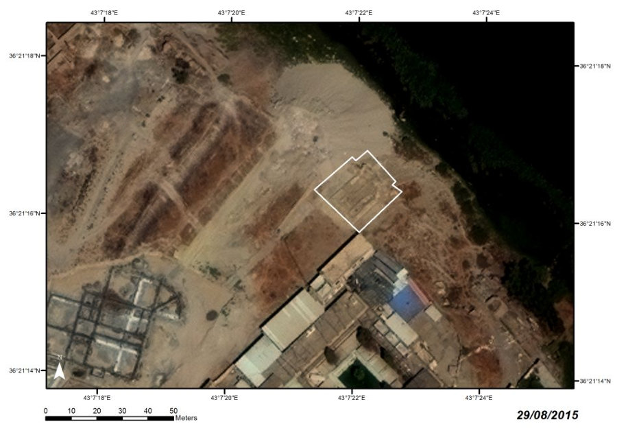
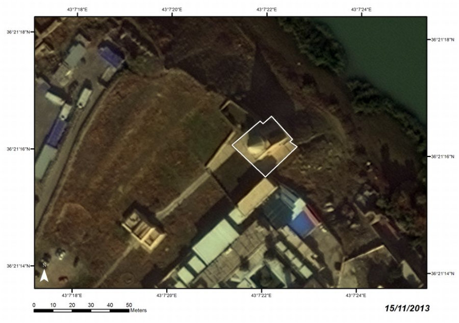
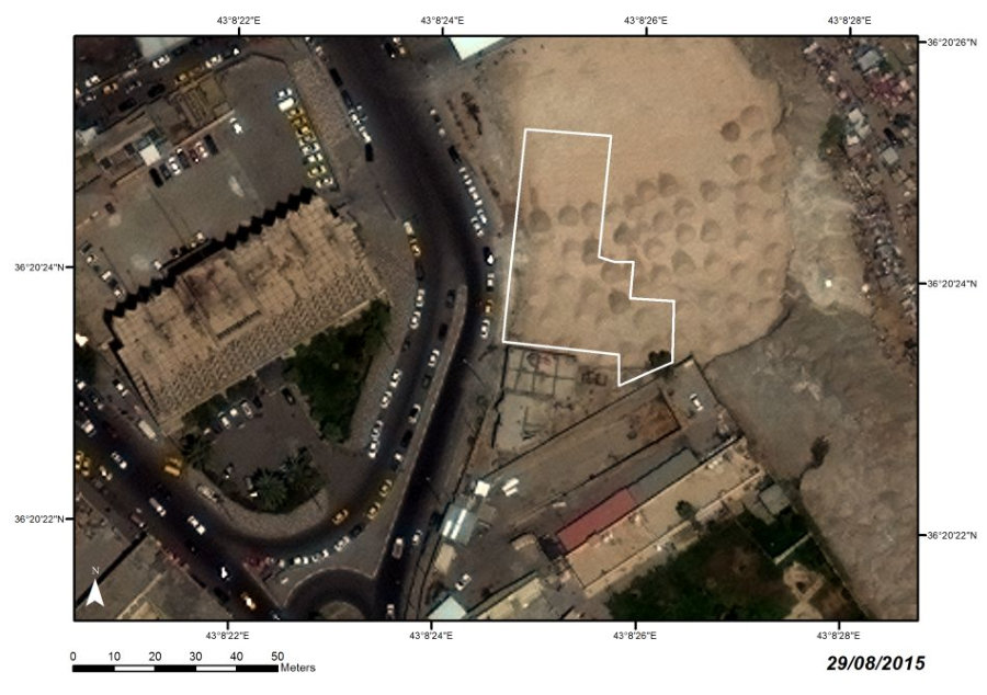
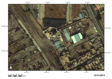
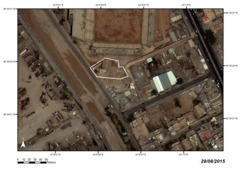
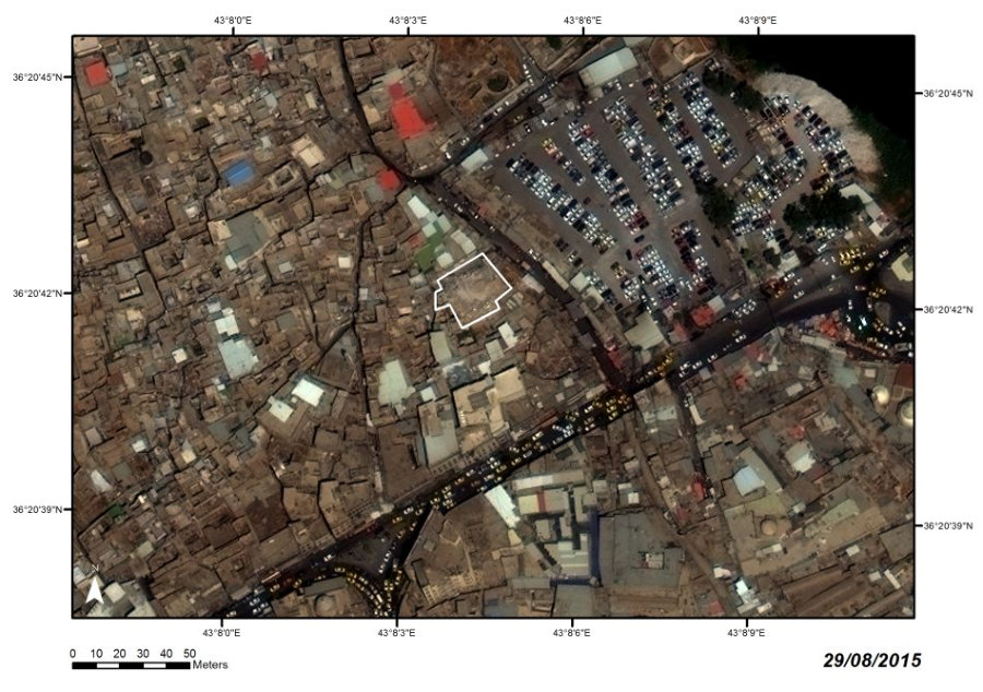
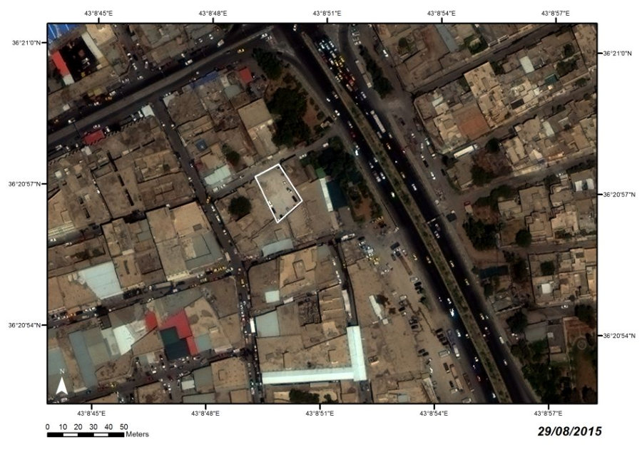
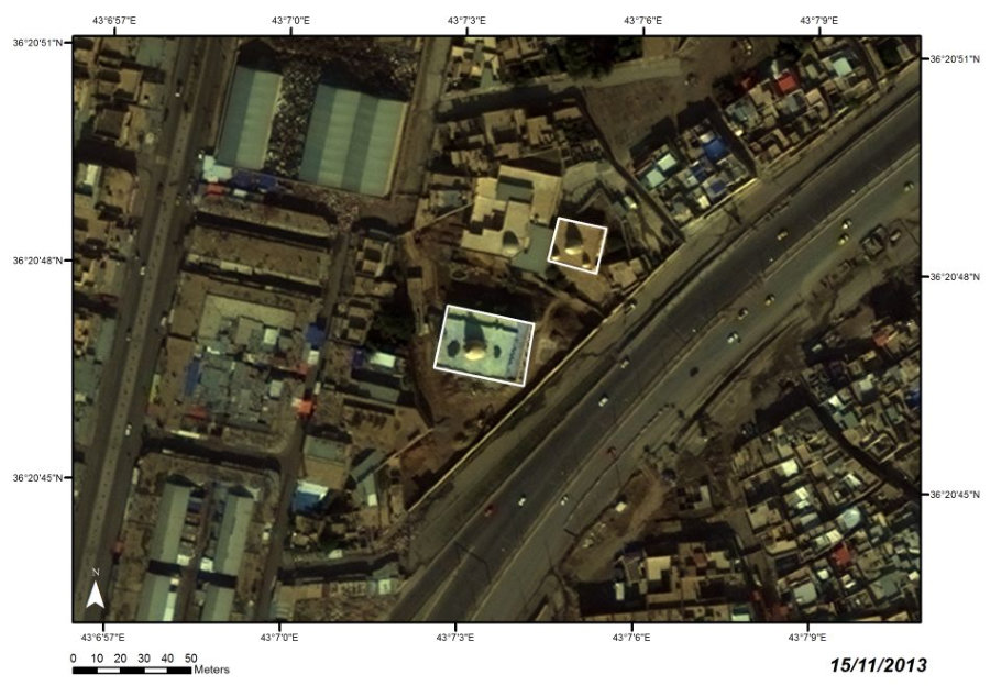
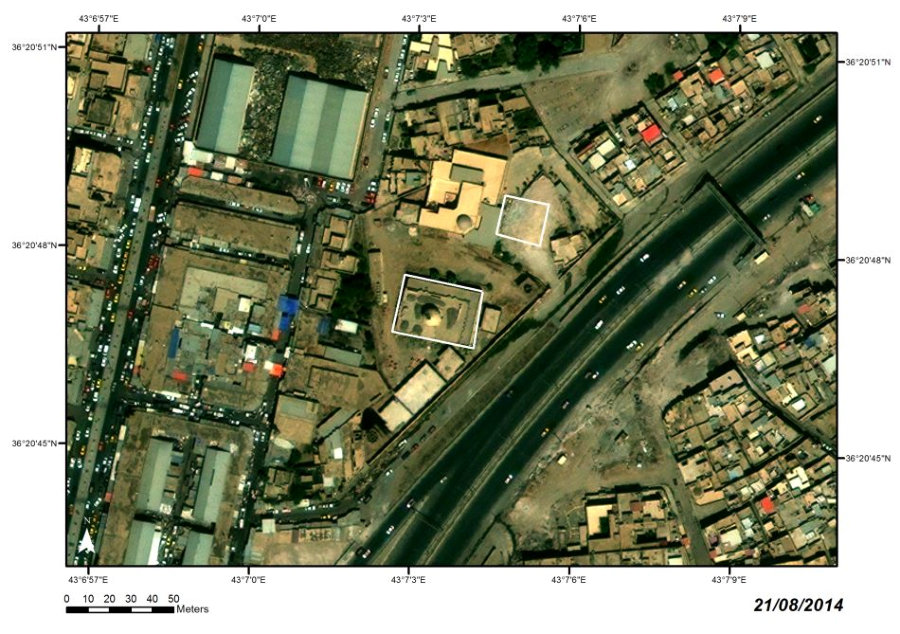
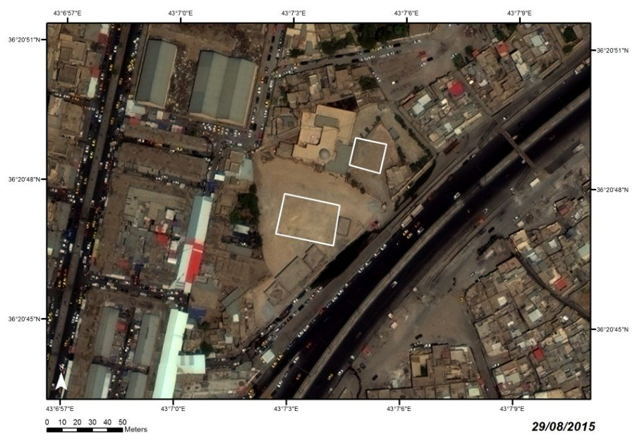
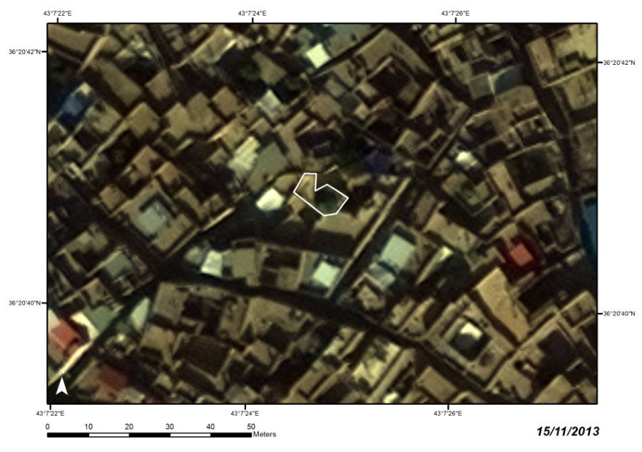
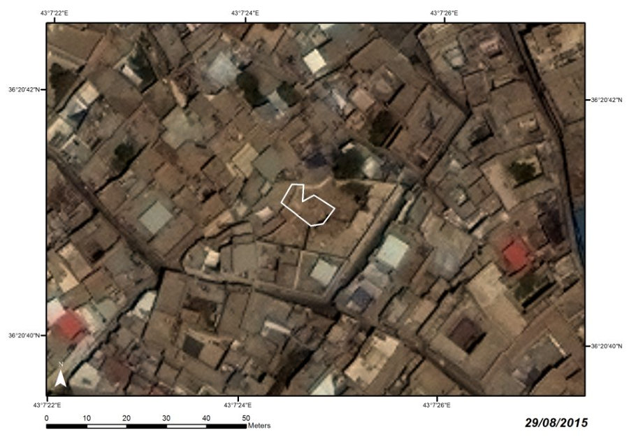
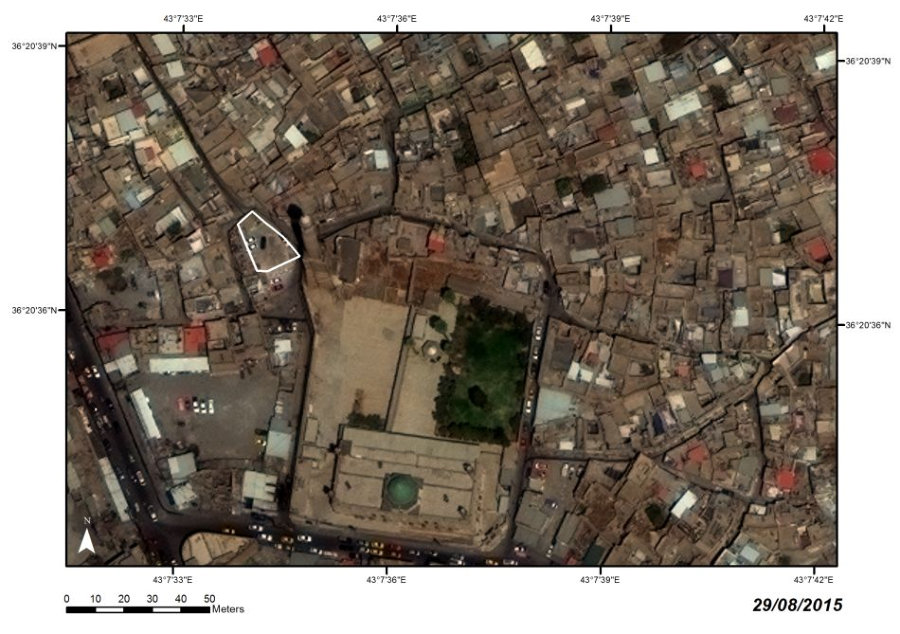
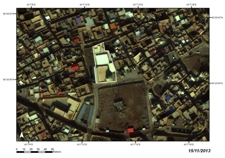
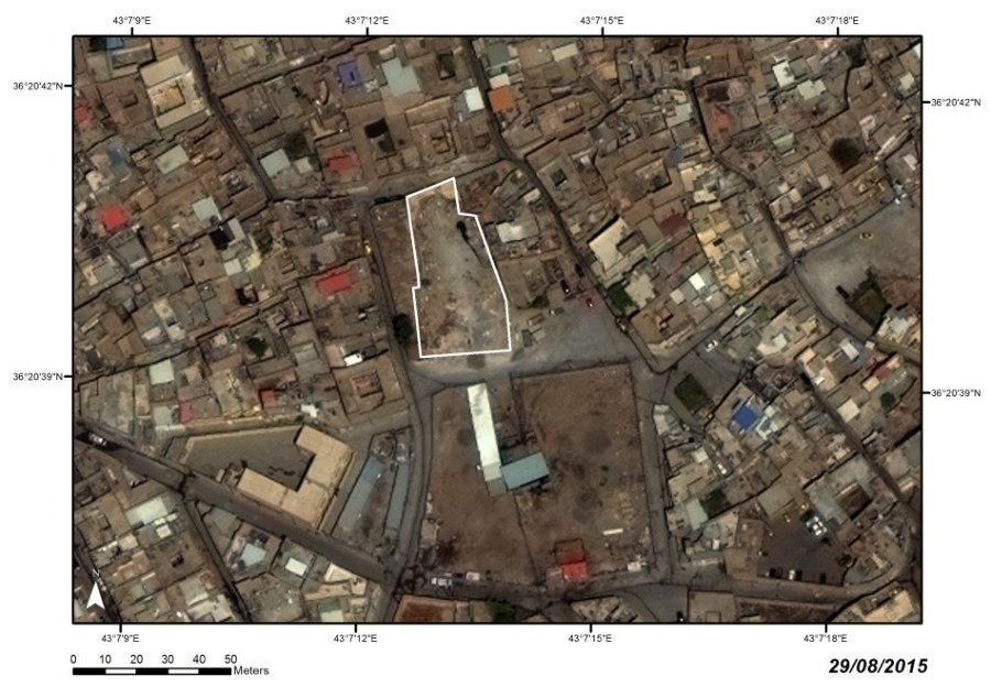
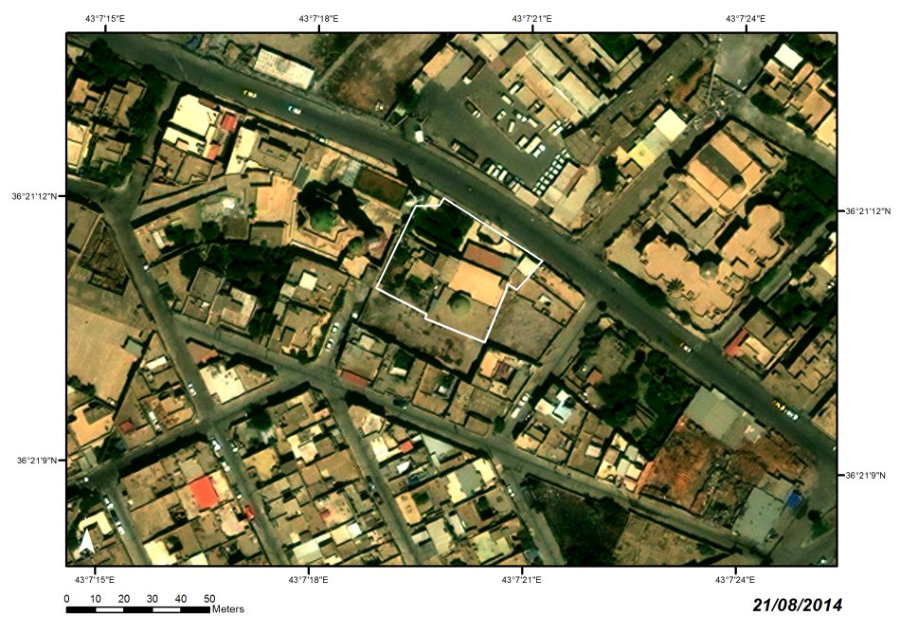
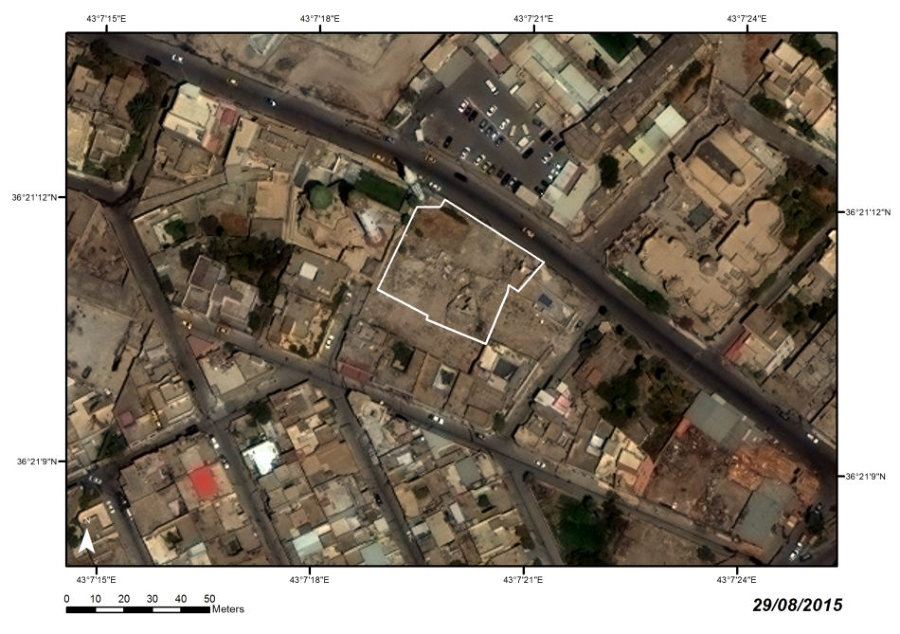
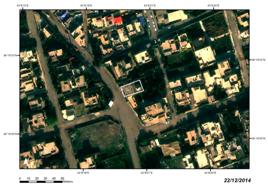
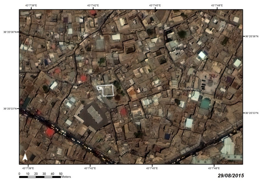
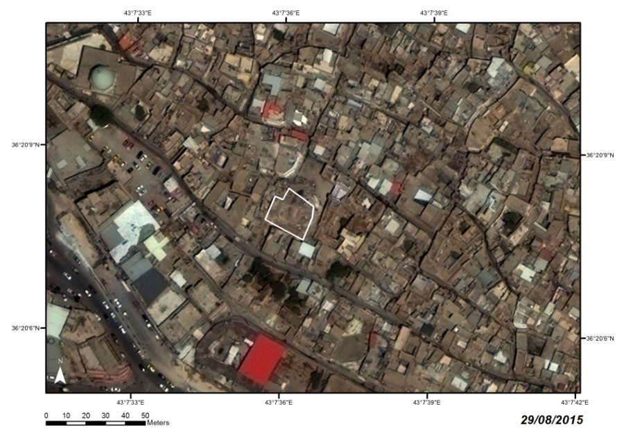
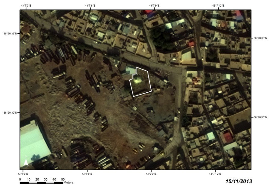
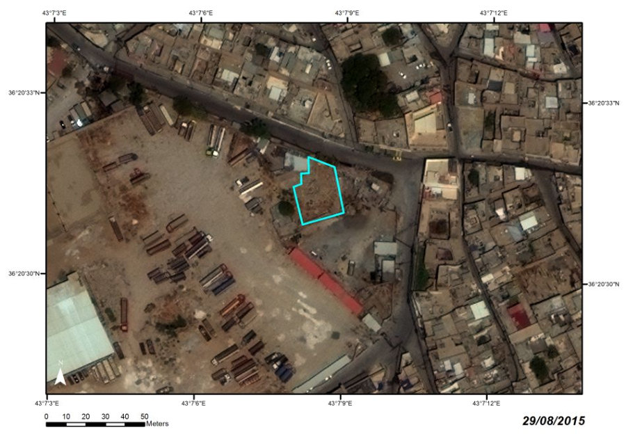
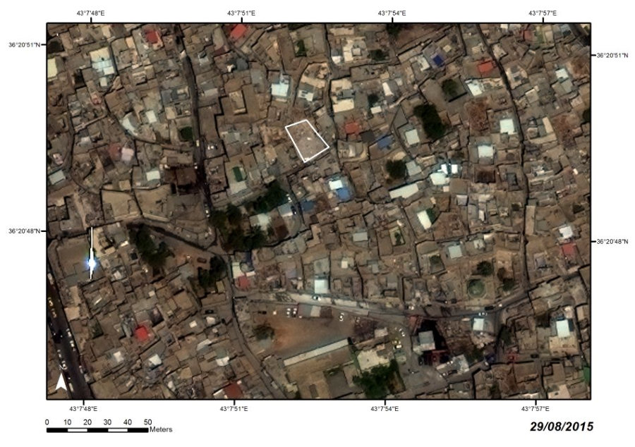
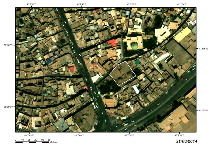
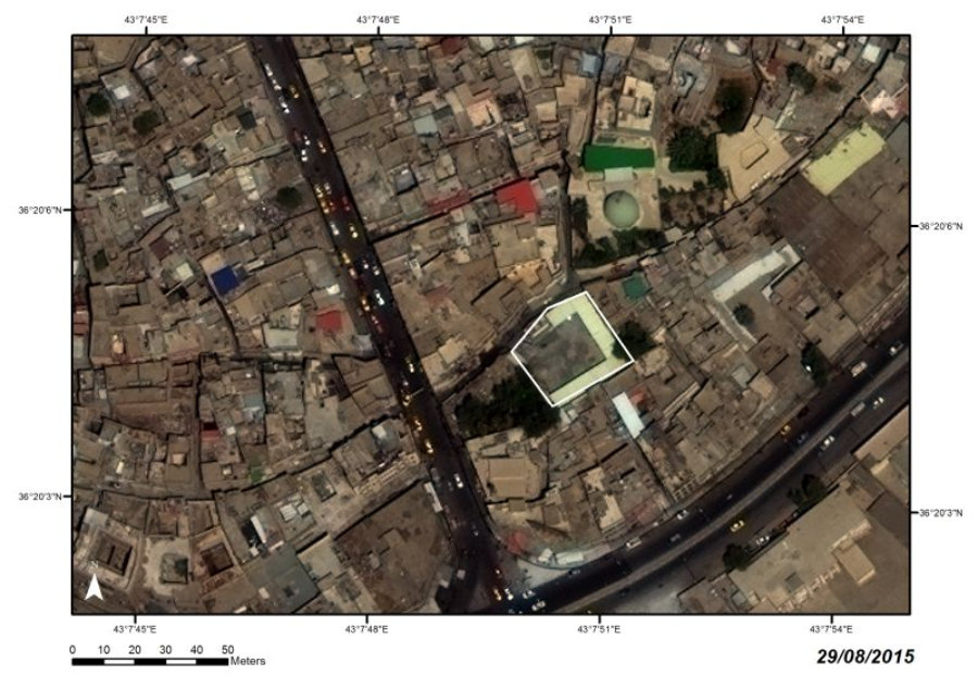
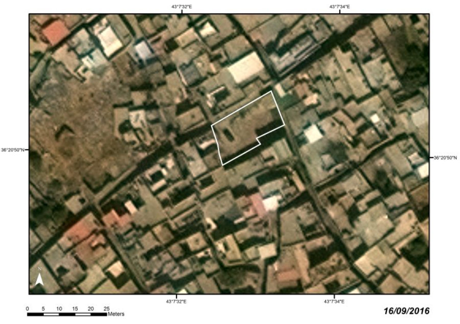
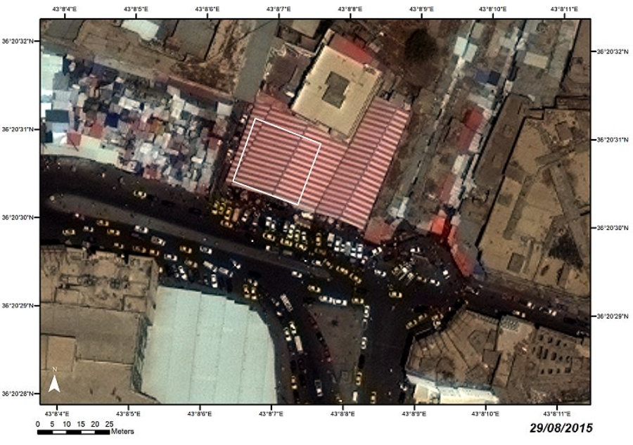
NW part of old Mosul, al-Shifa’ Quarter
Ottoman
LOCATION
Ruined (2 February 2015)
STATE
(AL-TAHIRA AL-KHARIJIYA)
AL-TAHIRA SYRIAC ORTHODOX CHURCH

C14
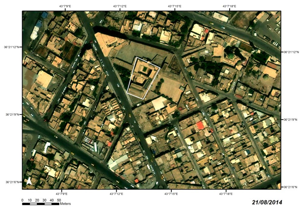


The
church
of
unknown
origin
was
built
anew
in
1744–1745
by
the
al-Jalili
family
after
the
devastating
siege
of
Mosul
by
Nader
Shah in 1743. It was a famous place of devotion and festivals.

Satellite images:
WorldView-2 and WorldView-3 © 2013–2016 DigitalGlobe, Inc., distributed by European Space Imaging GmbH/ARCDATA PRAHA, s.r.o.
![[x]](index_htm_files/close.png "Close")


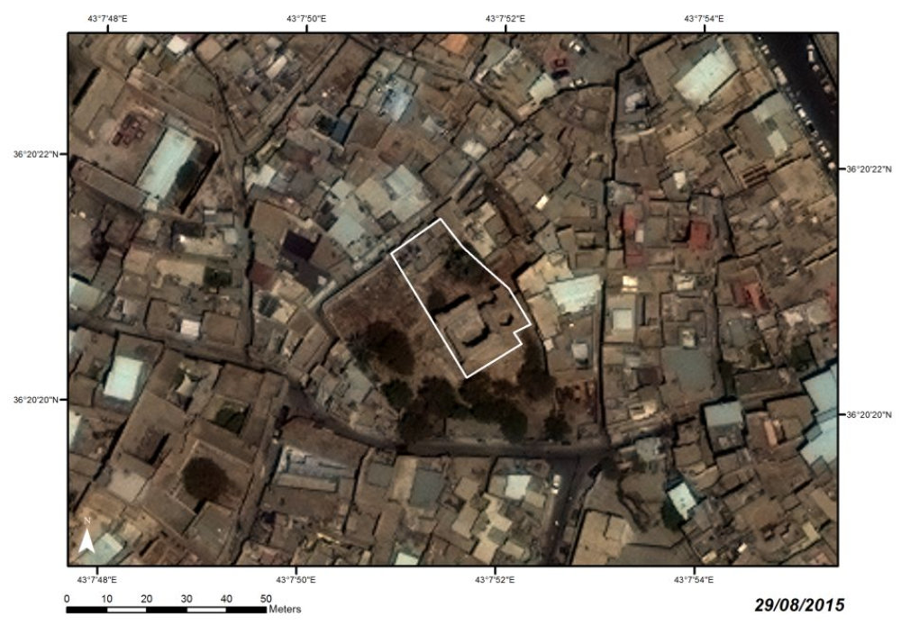
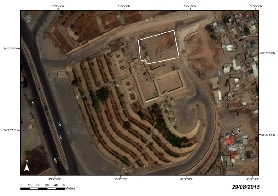
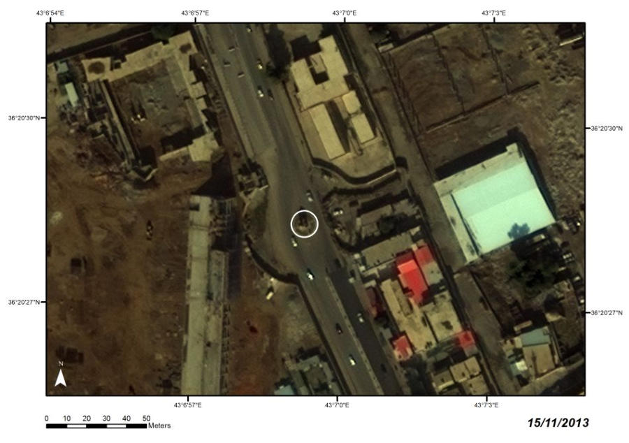
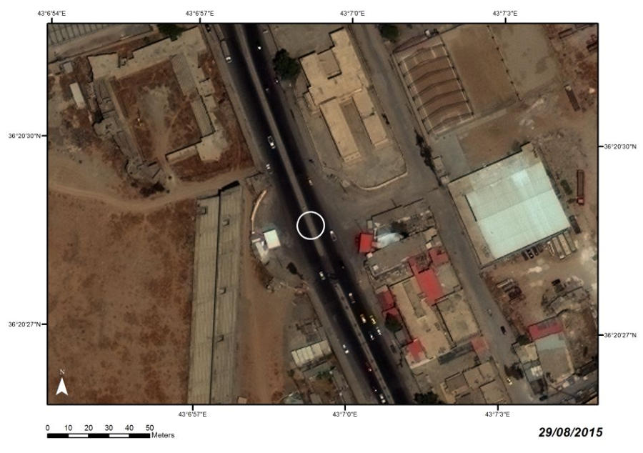
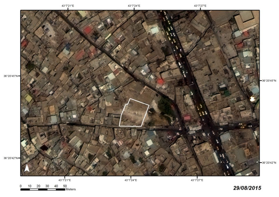
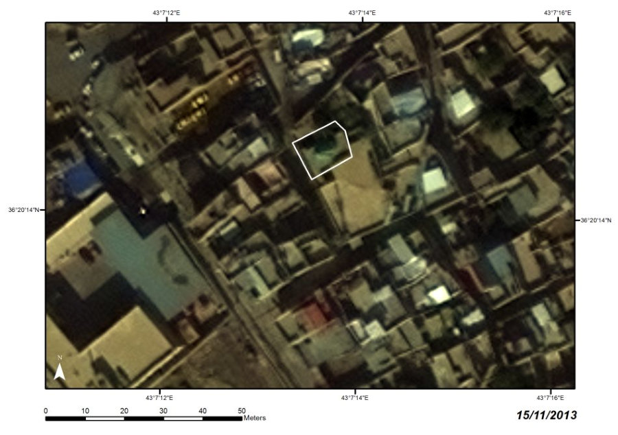
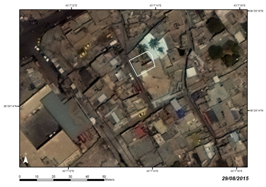
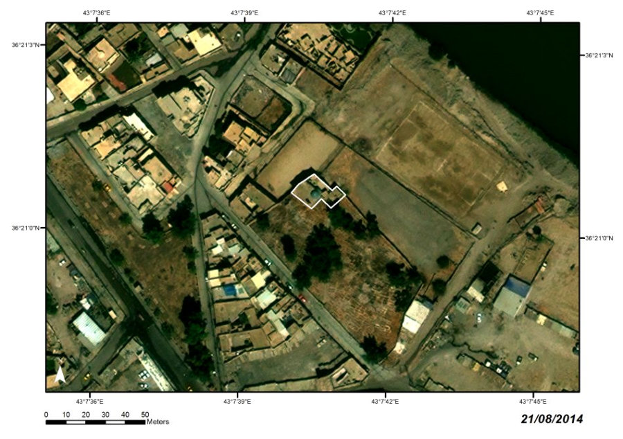
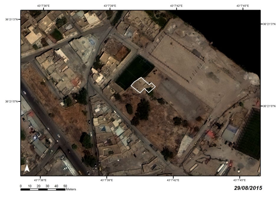
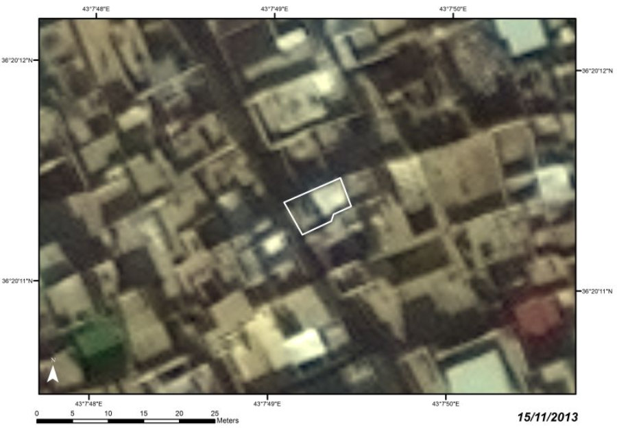
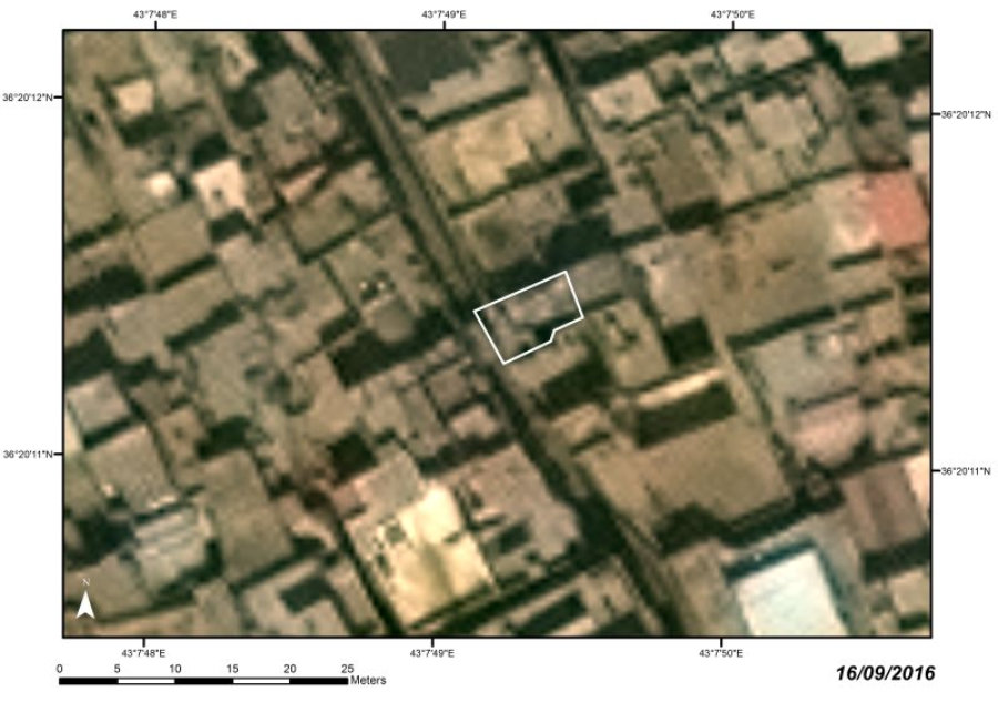
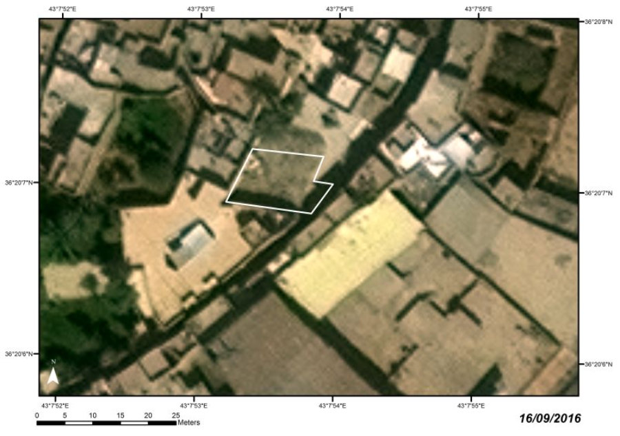
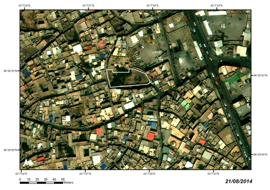
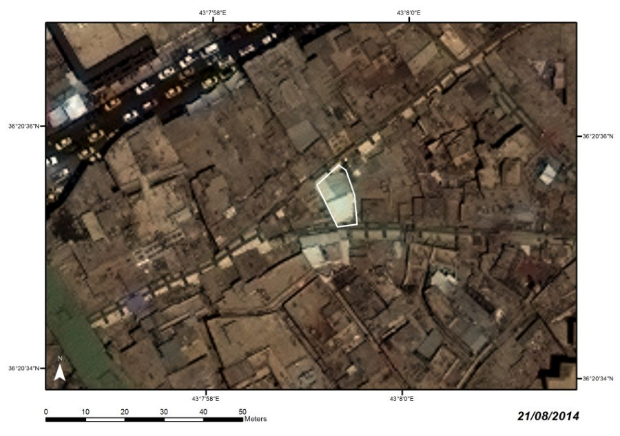
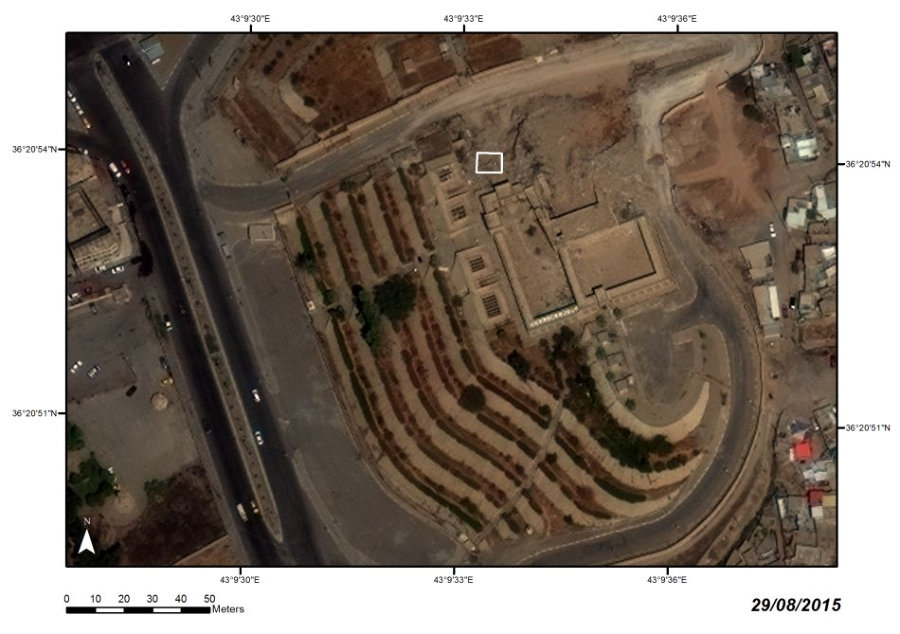
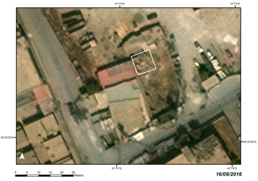
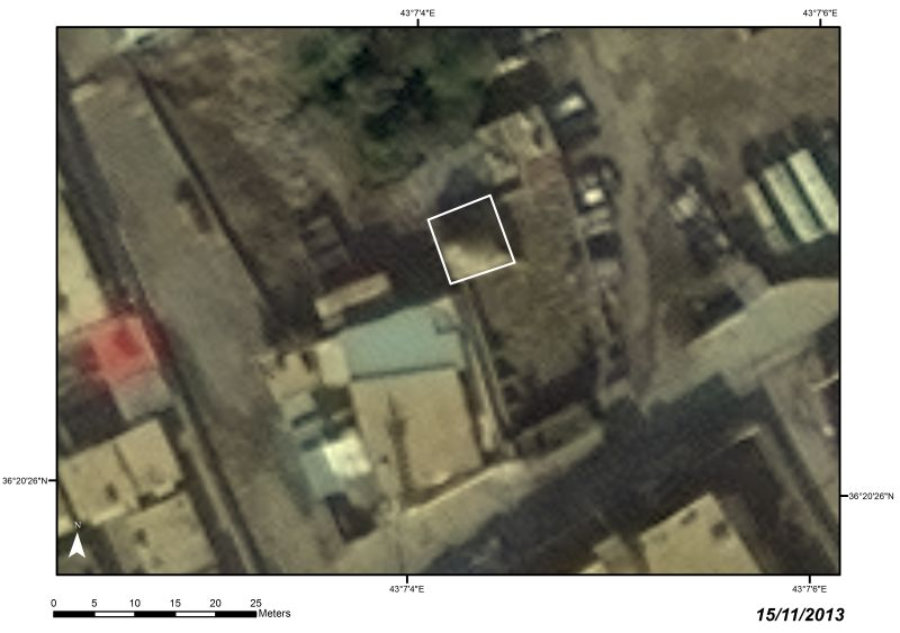
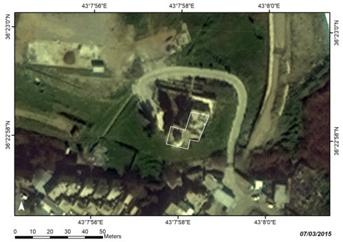
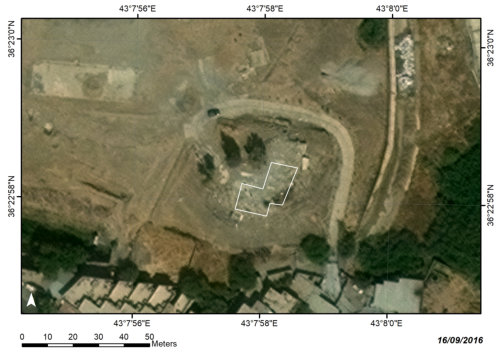
PERIOD
West Mosul, al-ʽUruba Quarter
Modern
LOCATION
Leveled (spring 2015)
STATE
ENGLISH WAR CEMETERY

C27
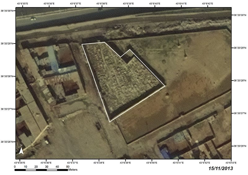


The
cemetery
was
founded
in
1918.
It
contained
more
than
349
graves
of
Commonwealth
and
Turkish
soldiers
who
fell
in
Iraq
during
the
two
world wars, as well as civilian graves (particularly consular burials).

Satellite images:
WorldView-2 and WorldView-3 © 2013–2016 DigitalGlobe, Inc., distributed by European Space Imaging GmbH/ARCDATA PRAHA, s.r.o.


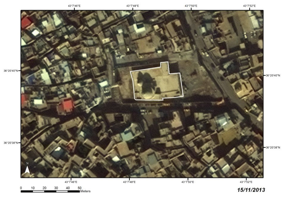
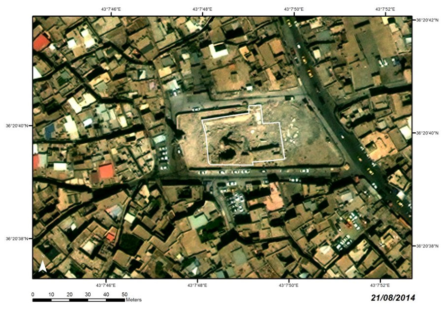
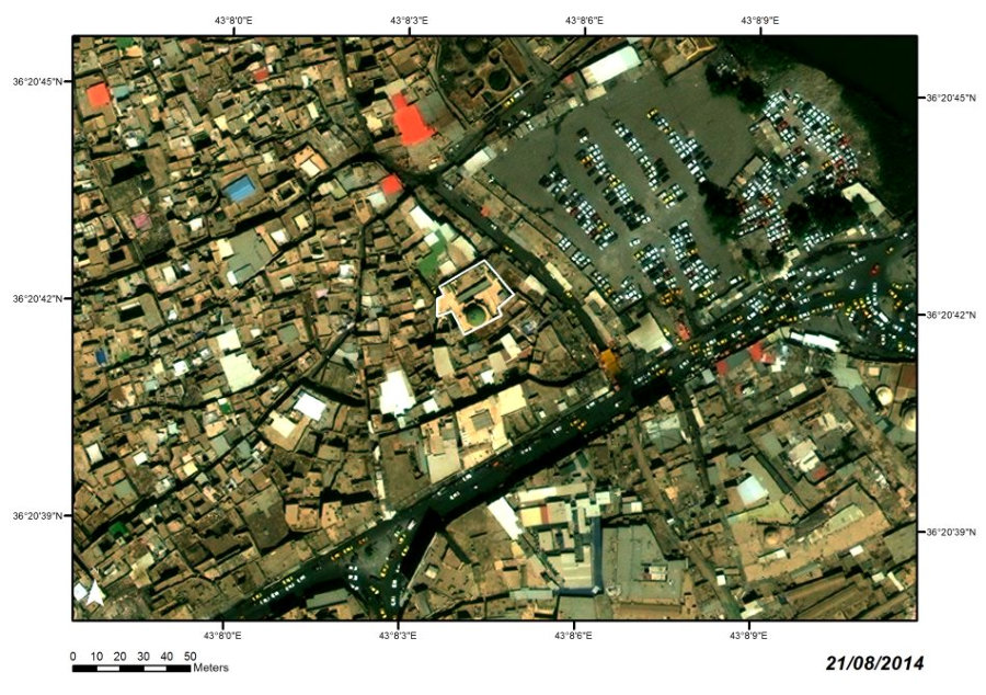
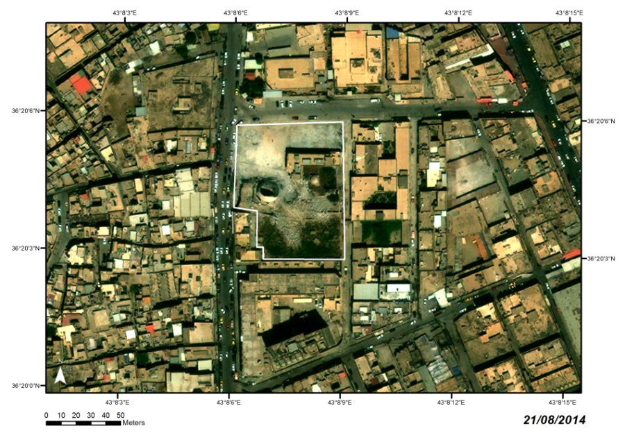
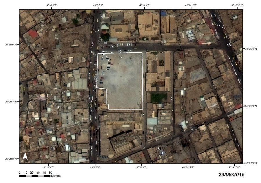
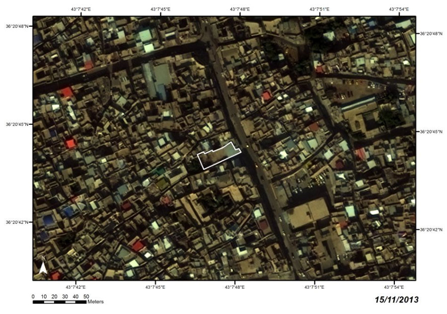
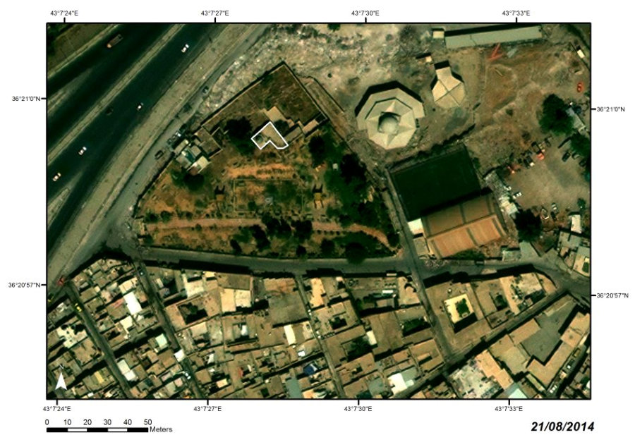
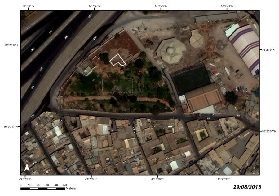
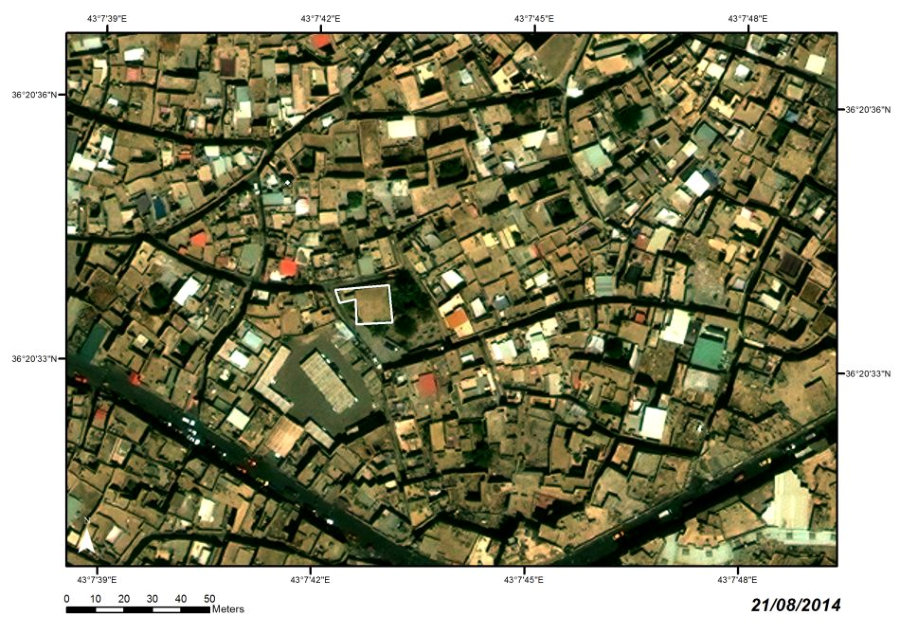
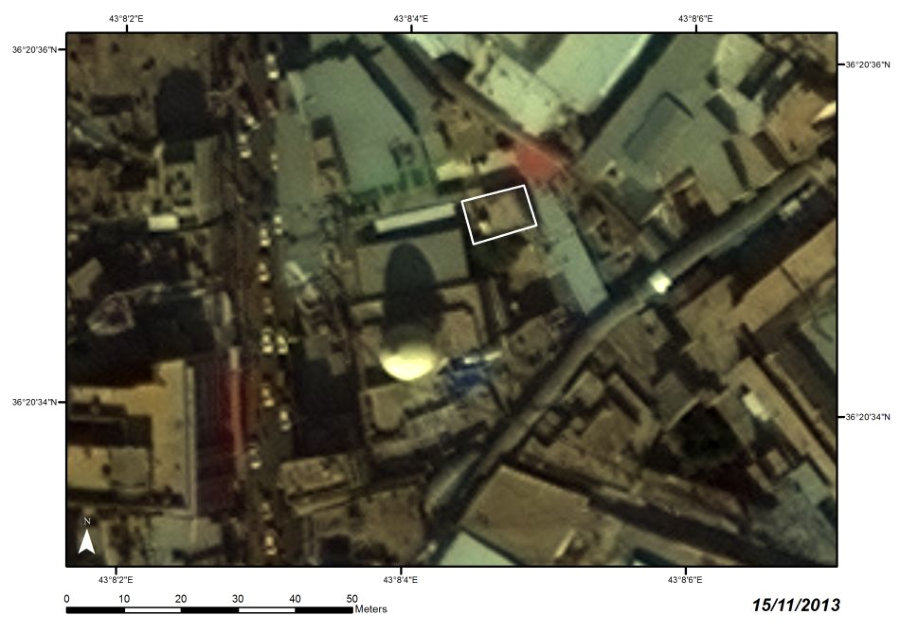
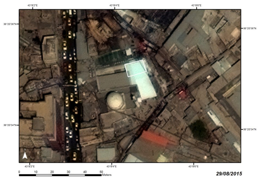
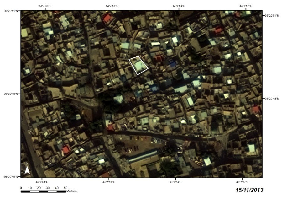
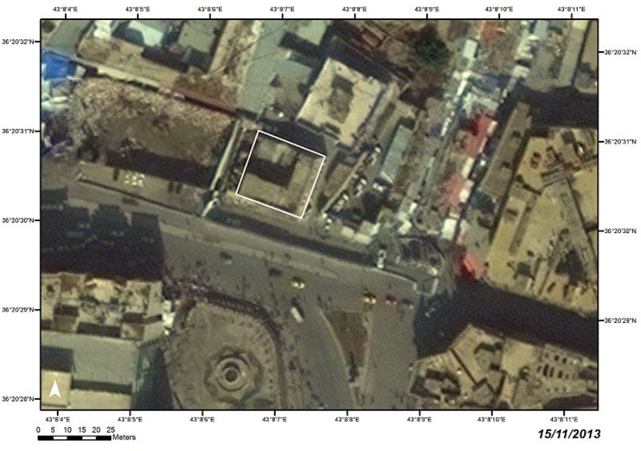
PERIOD
West Mosul, al-Jamiʽ al-Kabir
Neighborhood
Atabeg, rebuilt in the 1940s; the minaret
persisted in the original state
LOCATION
Ruined (21 June 2017)
STATE
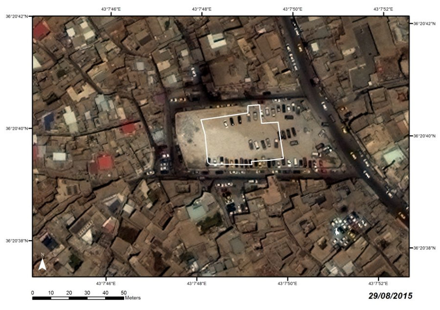
GREAT MOSQUE OF AL-NURI AND MINARET AL-HADBAʼ

I02-I03

The
mosque
was
founded
in
1170
by
Atabeg
Nur
al-Din
Mahmud
Zengi
as
the
second
congregational
mosque
in
the
city.
It
was
reconstructed
in
the
Aq
Qoyunlu
and
Ottoman
periods,
and
was
eventually
torn
down
and
built
anew
in
the
1940s.
The
mosque
was
the
most
significant
historical
building
and
symbolic
focus
of
the
old
city.
The
extraordinary
high
leaning
minaret,
the
only
fully
preserved
brick
minaret
from
the
Atabeg period in North Iraq, made it an unmistakable landmark.
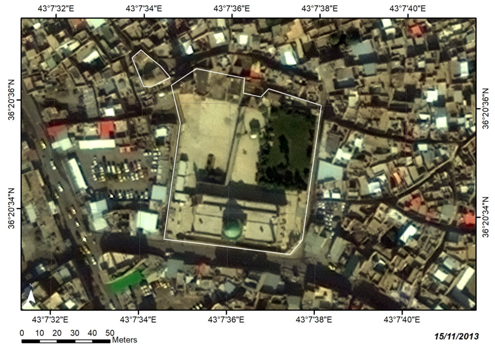
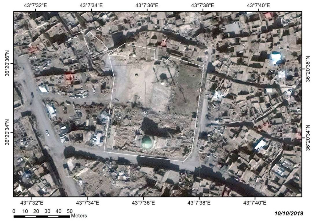


Satellite images:
WorldView-2 and WorldView-3 © 2013–2016 DigitalGlobe, Inc., distributed by European Space Imaging GmbH/ARCDATA PRAHA, s.r.o.


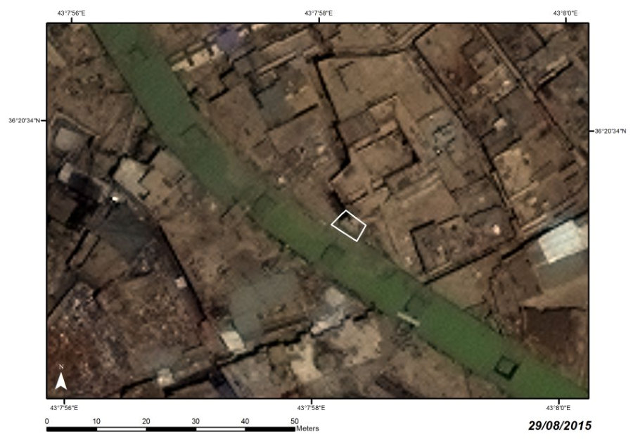
PERIOD
West bank of the Tigris, on the
northern edge of the old town
Atabeg
LOCATION
Razed (23 July 2014)
STATE
SHRINE OF IMAM YAHYA IBN AL-QASIM
MADRASA AL-BADRIYA

I04
Satellite images:
WorldView-2 and WorldView-3 © 2013–2016 DigitalGlobe, Inc., distributed by European Space Imaging GmbH/ARCDATA PRAHA, s.r.o.


The
shrine
was
constructed
by
Badr
al-Din
Lu
ʼ
lu
ʼ
in
1239–1240
in
the
vicinity
of
his
earlier
foundation
of
Madrasa
al-Badriya.
The
Ilkhanid
period
reconstruction
(from
the
beginning
of
the
14th
century
AD)
changed
its
appearance
and
symbolic
purpose,
but
thereafter
the
structure
remained
intact
until
recently,
representing
an
outstanding
example
of
Badr
al-Din’s
tower
shrines
and
a
distinctive
part
of
old
Mosul’s
panorama.
Its
complex,
valuable
interior
decoration,
including
a
partly
collapsed muqarnas dome, was destroyed together with the building.

PERIOD
Mahallat al-Imam ʽAwn al-Din
Atabeg
LOCATION
Ruined (24 July 2014)
STATE
SHRINE OF IMAM ʽAWN AL-DIN IBN AL-HASAN
I05
Satellite images:
WorldView-2 and WorldView-3 © 2013–2016 DigitalGlobe, Inc., distributed by European Space Imaging GmbH/ARCDATA PRAHA, s.r.o.


The
shrine
was
built
in
1248–1249
by
Badr
al-Din
Lu
ʼ
lu
ʼ
,
probably
on
the
site
of
an
earlier
building.
It
was
substantially
reconstructed
in
the
Ilkhanid
period
and
it
seems
probable
that
the
origin
of
the
marvellous
muqarnas
vault
could
be
dated
to
this
period.
The
sponsor
of
the
reconstruction
remains
unknown.
Later
Ottoman
refurbishment
stressed
the
adjacent
funerary
structure,
traditionally
called
al-Barma
or
Madfan
al-Ja
ʽ
fari
(a
Shi
ʽ
i
mausoleum),
which
was
furnished
with
two
valuable
portals transferred from the shrine.


PERIOD
West bank of the Tigris, on the southern
edge of the old town
Atabeg
LOCATION
Razed (26 February 2015)
STATE
MOSQUE OF AL-KHIDR
(al-Jami‛ al-Ahmar, al-Jami‛ al-Mujahidi)

I06
Satellite images:
WorldView-2 and WorldView-3 © 2013–2016 DigitalGlobe, Inc., distributed by European Space Imaging GmbH/ARCDATA PRAHA, s.r.o.


The
mosque
was
founded
by
Mujahid
al-Din
Qaymaz
in
1176.
After
its
completion
in
1180–1181
it
served
as
the
third
congregational
mosque
providing
religious
services
to
the
area
of
Mosul
ʼ
s
southern
suburb.
Athough
three
Ottoman
reconstructions
substantially
changed
its
appearance,
they
preserved
from
the
original
mosque
the
central
domed
space
with
its
stucco-
decorated outer mihrab niche.


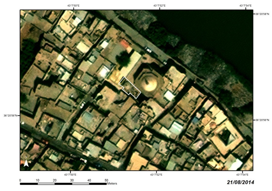
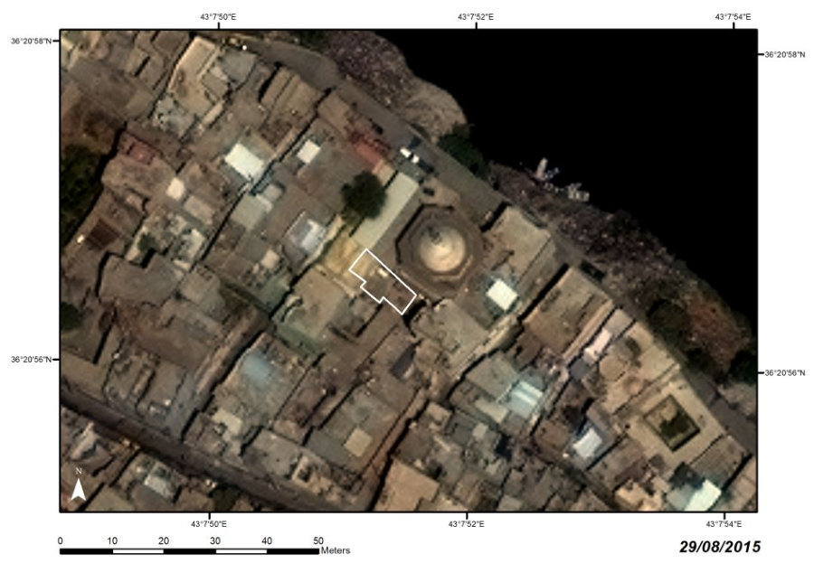
PERIOD
East Mosul, Tell al-Tawba, Niniveh
From the Assyrian period onward
LOCATION
Razed (24 July 2014)
STATE
MOSQUE AND TOMB OF NABI YUNUS (PROPHET JONAH)

I07
Satellite images:
WorldView-2 and WorldView-3 © 2013–2016 DigitalGlobe, Inc., distributed by European Space Imaging GmbH/ARCDATA PRAHA, s.r.o.


The
shrine,
one
of
the
most
popular
pilgrimage
sites
in
Iraq,
evolved
into
a
monumental
congregational
mosque
(jami
ʽ
)
under
the
reconstruction
by
Jalal
al-Din
Ibrahim
al-Khatani
in
1365–1366,
when
the
tomb
of
the
Prophet
Jonah
was
“rediscovered”
and
covered
with
a
dome.
A
conglomerate
of
the
tomb,
three
prayer
halls,
a
madrasa,
and
passages
most
probably
reused
an
old
complex
of
the
Nestorian
monastery
of
Mar
Yonan.
It was radically refurbished in the 1850s and again in the late 1980s.


PERIOD
West Mosul, Mahallat Bab al-Nabi
Unknown origin; Timurid and
Ottoman reconstructions
LOCATION
Razed (25 July 2014)
STATE
MOSQUE AND TOMB OF NABI JIRJIS (PROPHET GEORGE)

I08
Satellite images:
WorldView-2 and WorldView-3 © 2013–2016 DigitalGlobe, Inc., distributed by European Space Imaging GmbH/ARCDATA PRAHA, s.r.o.


The
first
evidence
of
the
mosque
and
tomb
of
al-Nabi
Jirjis
refers
to
1175–1176.
The
tomb,
apparently
the
oldest
nucleus
of
the
compound,
was,
however,
a
result
of
later
renovations.
In
1734–1740,
a
magnificent
complex,
consisting
of
a
spacious
mosque
and
two
additional
prayer
halls,
was
built
around
the
tomb,
and
was
repaired
many
times
afterwards.
Nabi
Jirjis
Mosque
represented
the
most
popular
center
of
pilgrimage,
veneration,
and
memory
in
west Mosul.


PERIOD
West Mosul, Bab Sinjar
Ottoman (with Atabeg origin)
LOCATION
Ruined (26 July 2014)
STATE
MOSQUE AND TOMB OF SHAYKH QADIB AL-BAN

I10
Satellite images:
WorldView-2 and WorldView-3 © 2013–2016 DigitalGlobe, Inc., distributed by European Space Imaging GmbH/ARCDATA PRAHA, s.r.o.


The
mosque
originated
as
a
ribat
of
Abu
ʽ
Abd
Allah
al-Husayn
Qadib
al-Ban,
where
he
was
burried
after
his
death
in
1177–1178.
The
site
was
substantially
rebuilt
in
1711,
eventually torn down, and built anew in 1957–1958.


PERIOD
West Mosul, Bab al-Tob
Late Ottoman, with earlier phases
LOCATION
Ruined (6 March 2015)
STATE
MOSQUE OF HAMU AL-QADU
TOMB OF ʽALAʼ AL-DIN

I11
Satellite images:
WorldView-2 and WorldView-3 © 2013–2016 DigitalGlobe, Inc., distributed by European Space Imaging GmbH/ARCDATA PRAHA, s.r.o.


The
mosque
originated
on
the
site
of
a
tomb
of
Shaykh
ʽ
Ala
ʼ
al-Din,
identified
by
local
tradition
as
the
son
of
the
famous
Sufi
ʽ
Abd
al-Qadir
al-Jilani
(1077–1166).
The
mosque
was
erected
by
al-Hajj
ʽ
Abd
Allah
Chalabi,
known
as
Hamu
al-Qadu,
in
1880–1881,
and
featured
a
unique
minaret
rising
up from the top of its dome.


PERIOD
West Mosul, south part
of the city, al-Nabi Shith Street
Ottoman; modern
LOCATION
Razed (25 July 2014)
STATE
MOSQUE OF NABI SHITH (PROPETH SETH)

I12
Satellite images: WorldView-2 and WorldView-3 © 2013–2016 DigitalGlobe, Inc., distributed by European Space Imaging
GmbH/ARCDATA PRAHA, s.r.o.


The
site
originated
as
a
modest
tomb
of
the
prophet
(17th
century)
with
a
small
mosque
(18th
century).
In
1815–1816,
the
governor
of
Mosul
Ahmad
Basha
ibn
Sulayman
Basha
al-Jalili
replaced
both
structures
with
a
large
congregational
mosque,
a
mausoleum
of
the
prophet,
a
madrasa,
and
his
own
tomb.
In
1977,
the
entire
complex,
with
the
exception
of
the
minaret,
was
demolished
and
a
new
concrete
mosque was erected at its place. The new minaret was built after 1983.

SHIʽI MOSQUE AND HUSAYNIYA RAWDAT AL-WADI

I14
Satellite images: WorldView-2 and WorldView-3 © 2013–2016 DigitalGlobe, Inc., distributed by European Space Imaging
GmbH/ARCDATA PRAHA, s.r.o.


PERIOD
East Mosul, al-Faysaliya Quarter
Modern
LOCATION
Razed (23 July 2014)
STATE
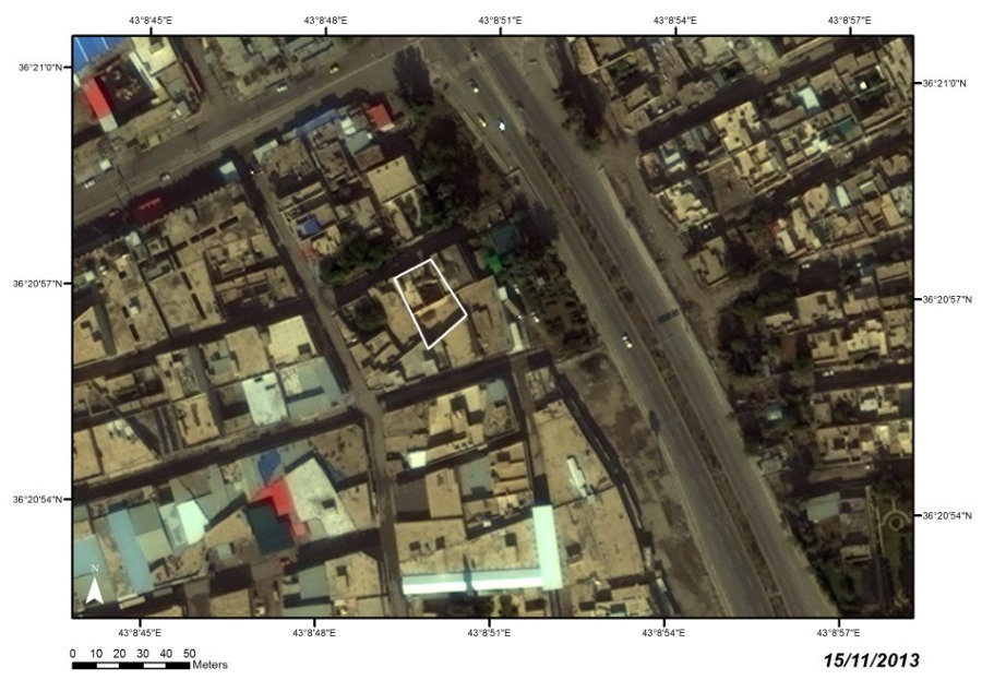


West Mosul, Ibn al-Athir Street
LOCATION
Razed (16 June 2014)
STATE
TOMB OF IBN AL-ATHIR (QABR AL-BINT)

I15
Satellite images: WorldView-2 and WorldView-3 © 2013–2016 DigitalGlobe, Inc., distributed by European Space Imaging
GmbH/ARCDATA PRAHA, s.r.o.
PERIOD
Modern


The
first
documented
reconstruction
of
the
tomb
of
the
famous
historian
ʽ
Izz
al-Din
Abu
al-Hasan
ibn
al-Athir
(d.
1233)
was
accomplished
in
1888–1889
by
ʽ
Abd
Allah
ibn
Hamu
al-Qadu.
During
the
construction
of
Ibn
al-Athir
Street
in
1938
the
tomb
was demolished and built again acccording to a completely new design.


PERIOD
W Mosul, Ra’s al-Kur
Atabeg
LOCATION
Ruined (11 March 2015)
STATE
MOSQUE AND SHRINE OF IMAM IBRAHIM

I16
Satellite images: WorldView-2 and WorldView-3 © 2013–2016 DigitalGlobe, Inc., distributed by European Space Imaging
GmbH/ARCDATA PRAHA, s.r.o.


The
mosque
was
founded
by
emir
Ibrahim
al-Muhrani
al-Jarrahi,
the
governor
of
the
al-Jarrahiya
fortress,
around
the
mid-12th
century.
The
adjacent
tomb
was
originally
dedicated
to
his
wife
Hanifa
Khatun.
Only
in
the
Ilkhanid
period
(according
to
the
inscription
originating
from
1330–1331)
was
the
tomb
transformed
into
a
shrine
dedicated
to
Imam
Ibrahim
(or,
more
precisely,
to
his
anonymous
son/descendant,
as
stated
on
the
lintel
of
a
window).
The
site
was
substantially reconstructed in the late Ottoman period.


PERIOD
West Mosul, Mahallat al-Shaykh Fathi
Unknown origin; Late Ottoman
reconstructions
LOCATION
Two buildings of the complex razed,
the mosque still standing
STATE
MOSQUE AND TOMB OF SHAYKH FATHI

I18
Satellite images: WorldView-2 and WorldView-3 © 2013–2016 DigitalGlobe, Inc., distributed by European Space Imaging
GmbH/ARCDATA PRAHA, s.r.o.


The
patron
of
the
site,
Shaykh
Fathi,
is
of
uncertain
identity.
He
lived
either
in
the
8th
or
9th
century
AD.
The
first
reconstruction
of
the
site
might
have
happened
in
the
Atabeg
period,
as
the
form
of
two
commemorative
flat
mihrabs
from
inside
the
tomb
indicates.
After
repeated
renovations
(1718–1719,
1842–1843),
the
tomb
with
the
adjacent
small
prayer
hall
was
eventually replaced by a modern structure in 2001.


PERIOD
West Mosul, Mahallat al-Shaykh Abu
al-ʽAlaʼ
Ottoman
LOCATION
Ruined (24 July 2014)
STATE
MOSQUE OF SHAYKH ABU AL-‛ALAʼ

I19
Satellite images:
WorldView-2 and WorldView-3 © 2013–2016 DigitalGlobe, Inc., distributed by European Space Imaging GmbH/ARCDATA PRAHA, s.r.o.


The
date
of
the
mosque
ʼ
s
construction
as
well
as
the
identity
of
the
eponymous
shaykh
are
unknown.
The
earliest
evidence
of
the
building
comes
from
1762–1763.
The
mosque
was
reconstructed
in
1878–1879
and
again
in
1945–1946.


PERIOD
West Mosul, Mahallat Jamshid
Ottoman (19th century)
LOCATION
Ruined (23 July 2014)
STATE
MOSQUE AND TOMB OF NABI DANIYAL

I21
Satellite images:
WorldView-2 and WorldView-3 © 2013–2016 DigitalGlobe, Inc., distributed by European Space Imaging GmbH/ARCDATA PRAHA, s.r.o.


The
mosque
was
founded
by
Ma
ʽ
ruf
ibn
Ibrahim
al-Sulayman
in
1813–1814.
Only
in
1842–1843
was
the
alleged
tomb
of
the
Prophet
Daniel
discovered
within
the
mosque
ʼ
s
compound
by
Mosul
ʼ
s
governor
Muhammad
Pasha
Inje
Bayraqdar,
and
covered
with
a
domed
structure.
Concurrently,
the
mosque
was
reconstructed
and
a
schoolroom
established
within
the
complex.
The
site
was
substantially rebuilt in 1980–1981.

PERIOD
West bank of the Tigris, al-Midan
Neighborhood
Ottoman
LOCATION
Ruined (reported on 2 September 2014)
STATE
TAKIYA AND TOMB OF MUHAMMAD AL-AFGHANI (SHAYKH AL-SHATT)

I22
Satellite images:
WorldView-2 and WorldView-3 © 2013–2016 DigitalGlobe, Inc., distributed by European Space Imaging GmbH/ARCDATA PRAHA, s.r.o.


The
takiya
was
built
in
the
courtyard
of
the
al-Shahwan
Mosque
(alias
Shaykh
al-Shatt
Mosque)
by
the
Sufi
Muhammad
Efendi
al-Afghani
(d.
1899)
in
the
second
half
of
the
19th
century.
After
his
death
he
was
interred
in
the
takiya.
The site was reconstructed in 2000.


PERIOD
West Mosul, NW of the al-Nuri Mosque
Unknown origin; Ilkhanid
LOCATION
Razed (24 July 2014)
STATE
SHRINE OF IMAM ‛ALI AL-ASGHAR

I28
Satellite images:
WorldView-2 and WorldView-3 © 2013–2016 DigitalGlobe, Inc., distributed by European Space Imaging GmbH/ARCDATA PRAHA, s.r.o.


The
shrine,
traditionally
identified—without
any
support
in
sources—with
the
earlier
Seljuq
madrasa
of
Nizam
al-Mulk
(11th
century),
most
likely
originated
only
in
the
Ilkhanid
period
(1330s),
as
was
epigraphically
attested
on
the
tomb
ʼ
s
window.
The
cult
of
Imam
ʽ
Ali
al-Asghar
was
further
promoted
in
the
Jala
ʼ
irid
period
(inscriptions
on
wooden
sarcophagus).
The
activities
of
Badr
al-Din
Lu
ʼ
lu
ʼ
,
traditionally
associated
with
the
promotion
of
the
cult
of
Imam
ʽ
Ali
al-
Asghar
at
this
site
in
the
Atabeg
period,
must
also
be
ruled
out
due
to
a
lack
of
supporting evidence.


PERIOD
West Mosul, Mahallat Bab
al-Masjid
Ottoman
LOCATION
Ruined (30 December 2014)
STATE
MOSQUE OF SULTAN UWAYS
AND ADJACENT CEMETERY
I29
Satellite images:
WorldView-2 and WorldView-3 © 2013–2016 DigitalGlobe, Inc., distributed by European Space Imaging GmbH/ARCDATA PRAHA, s.r.o.


The
founding
period
of
the
complex
of
Sultan
Uways
Mosque
cannot
be
convincingly
determined.
Still,
an
Atabeg
or
Jala
ʼ
irid
origin
should
be
regarded
as
plausible.The
purpose
of
the
complex
was
either
funerary
or
ritual
(a
Sufi
takiya),
or
a
combination
of
both.
The
later
Ottoman
mosque
erected
in
1682–1684
by
al-Hajj
Jum
ʽ
a
al-Hadithi
was
a
representative
example
of
Jalili-Period
mosque
architecture,
which
persisted—though
in
architecturally
degraded form—until 2014.


PERIOD
West Mosul, al-Tawalib Quarter
Atabeg
LOCATION
Ruined (2 September 2014)
STATE
SHRINE OF IMAM ‛ABD AL-RAHMAN
MADRASA AL-‛IZZIYA

I34
Satellite images:
WorldView-2 and WorldView-3 © 2013–2016 DigitalGlobe, Inc., distributed by European Space Imaging GmbH/ARCDATA PRAHA, s.r.o.


The
shrine
originated
as
part
of
Madrasa
al-
ʽ
Izziyya,
founded
by
Atabeg
ʽ
Izz
al-Din
Mas
ʽ
ud
ibn
Qutbuddin
Mawdud
(1180–1193).
The
traditionally
attributed
role
of
Badr
al-Din
Lu
ʼ
lu
ʼ
in
the
transformation
of
the
site
to
the
shrine
of
Imam
ʽ
Abd
al-Rahman
should
be,
for
the
time
being,
ruled
out
due
to
a
lack
of
any
supporting
evidence.
Its
connection
with
Imam
ʽ
Abd
al-Rahman
can
only
be proven by sources from the Ottoman period.


PERIOD
West Mosul, Mahallat al-Imam al-Bahir
Atabeg (shrine); Ottoman (mosque)
LOCATION
Razed (2 September 2014)
STATE
SHRINE AND MOSQUE OF IMAM AL-BAHIR
I35
Satellite images:
WorldView-2 and WorldView-3 © 2013–2016 DigitalGlobe, Inc., distributed by European Space Imaging GmbH/ARCDATA PRAHA, s.r.o.


The
shrine
can
be
linked
to
the
patronage
of
Badr
al-Din
Lu’lu’
(d.
1239),
though
it
was
substantially
rebuilt
in
the
Ilkhanid
period,
when
the
shrine
was
reinterpreted
through
the
symbolism
of
Twelver
Shi
ʽ
a.
The
appearance
of
the
site
completely
changed
during
the
Ottoman
period
(reconstruction
by
Sayyid
al-Bektash
in
the
18th
century)
and
in
the
modern
era
(1939–1940,
1987,
1996,
and
2000s).
The
most
valuable
elements
of
the
interior
decoration—the
marvellous
zoomorphic
portal,
wooden
door,
mihrab,
and
fragmentarily
preserved
intarsed
marble
panels—were
transferred to museums.


PERIOD
Turkmen; Ottoman
Ruined (24 July 2014)
STATE
SHRINE OF IMAM ‛ALI AL-HADI

I36
Satellite images:
WorldView-2 and WorldView-3 © 2013–2016 DigitalGlobe, Inc., distributed by European Space Imaging GmbH/ARCDATA PRAHA, s.r.o.
West Mosul, al-Mahmudayn
Neighborhood


LOCATION

The
origin
of
the
shrine,
which
was
dedicated
to
ʽ
Ali,
the
son/descendant
of
the
10th
Twelver
Imam
ʽ
Ali
al-Hadi
(according
to
the
inscription
on
the
lid
of
the
sarcophagus),
is
unknown.
Only
the
resemblance
of
some
decoration
on
the
sarcophagus
to
that
in
the
niche
of
the
mihrab
in
the
Imam
al-Bahir
Shrine
makes
it
possible
to
link
it
to
the
late
13th
century.
The
mosque
underwent
several
reconstructions
and,
after
it
became dilapidated, was replaced by a large new building in 1971.


PERIOD
West Mosul, Mahallat al-Shifa’
Atabeg
LOCATION
Ruined (30 December 2014)
STATE
MOSQUE AND SHRINE OF IMAM MUHSIN
MADRASA AL-NURIYA

I37
Satellite images:
WorldView-2 and WorldView-3 © 2013–2016 DigitalGlobe, Inc., distributed by European Space Imaging GmbH/ARCDATA PRAHA, s.r.o.


The
site
originated
as
part
of
the
funerary
Madrasa
al-Nuriyya
of
Atabeg
ruler
Nur
al-
Din
Arslan
Shah
(reigned
1193–1211).
The
emergence
of
the
site
as
the
Shrine
of
Imam
Muhsin
cannot
be
even
approximately
dated;
the
traditionally
accepted
involvement
of
Badr
al-Din
Lu
ʼ
lu
ʼ
in
this
transformation
should
be
rejected
due
to
the
absence
of
any
historical
evidence.
It
could
have
some
connection
to
the
disappearance
of
reports
of
Madrasa
al-Nuriya
after
1315,
which
would
make
it
a
result
of
the
Ilkhanid-period
development.
The
historical
structure
was
replaced
by
a
new mosque in 1958–1959.


PERIOD
West Mosul, al-Midan Neighborhood
Zengid
LOCATION
Ruined (reported on 2 September 2014)
STATE
MOSQUE AND TOMB OF ‛ISA DADAH AND ADJACENT CEMETERY

I44
Satellite images:
WorldView-2 and WorldView-3 © 2013–2016 DigitalGlobe, Inc., distributed by European Space Imaging GmbH/ARCDATA PRAHA, s.r.o.


The
site
probably
originated
as
a
Sufi
lodge
(ribat)
built
by
the
Atabeg
ruler
Sayf
al-Din
Ghazi
I
(ruled
1146–1149).
Later
it
became
known
as
the
mosque
of
ʽ
Isa
Dadah,
a
Sufi
shaykh
of
unknown
identity
(Mosul
tradition
considers
him
to
be
the
son
of
ʽ
Abd
al-Qadir
al-Jilani).
The
mosque
was
reconstructed
in
1986.
The
cemetery
had
a
long
historical
tradition.
It
was
referred
to
in
the
works
of
Mosul
ʼ
s
historians
from
the
end
of
the
18th
century.


PERIOD
South Mosul, al-Tayaran
Quarter
Modern
LOCATION
Ruined (1 January 2015)
STATE
MOSQUE AND TOMB OF SHAYKH ʽAJIL AL-YAWAR

I47
Satellite images:
WorldView-2 and WorldView-3 © 2013–2016 DigitalGlobe, Inc., distributed by European Space Imaging GmbH/ARCDATA PRAHA, s.r.o.


The
mosque
was
built
in
1943
on
the
site
of
the
tomb
of
ʽ
Ajil
al-Yawar
(1882–1940),
the
shaykh
of
the
Shammar
tribe
and
Iraqi
politician.
The
tomb
was
situated
in
the
mosque
ʼ
s courtyard.


PERIOD
West Mosul, Mahallat al-Shaykh
Muhammad
Ottoman
LOCATION
Ruined (reported on 31 December 2014)
STATE
Satellite images:
WorldView-2 and WorldView-3 © 2013–2016 DigitalGlobe, Inc., distributed by European Space Imaging GmbH/ARCDATA PRAHA, s.r.o.


MOSQUE AND MADRASA OF AL-RIDWANI

I48

The
complex
was
founded
and
maintained
for
generations
by
the
al-Ridwani
family.
The
mosque
was
built
by
Shaykh
ʽ
Abd
al-Razzaq
al-Ridwani
in
1795–1796,
and
the
madrasa
by
his
grandson
Muhammad
al-Ridwani
in
1911–1912
or
1921.
The complex was reconstructed in 1986 and 2006.

PERIOD
West Mosul, Mahallat al-Nabi Jirjis, 160 m
east of al-Nuri Mosque
Atabeg? (shrine); Mongol? (mosque);
Ottoman and modern reconstructions
LOCATION
Ruined (9 March 2015)
STATE
HAMMAM AL-SARAY MOSQUE AND SHRINE OF AL-SITT NAFISA

I50
Satellite images:
WorldView-2 and WorldView-3 © 2013–2016 DigitalGlobe, Inc., distributed by European Space Imaging GmbH/ARCDATA PRAHA, s.r.o.

The
origin
of
both
structures,
connected
into
one
complex
in
1926–1927,
is
obscure.
It
has
been
speculated
that
the
mosque
originated
in
the
Ilkhanid
period
as
part
of
the
Mongol
military-administrative
district.
The
earliest
evidence,
however,
confirms
its
existence
only
in
the
16th
century
(foundation/reconstruction
by
Shaykh
Yunus).
The
shrine
might
have
been
of
Atabeg
origin,
though
any
reliable
evidence
is
missing.
The
complex
ʼ
s
layout was substantially changed by the renovation in 1985.


PERIOD
W Mosul, Bab al-Jadid
Ottoman
LOCATION
Ruined
STATE
MOSQUE AND TOMB OF SHAYKH MUHAMMAD AL-ABARIQI

I51
Satellite images:
WorldView-2 and WorldView-3 © 2013–2016 DigitalGlobe, Inc., distributed by European Space Imaging GmbH/ARCDATA PRAHA, s.r.o.


The
mosque
was
built
next
to
the
tomb
of
Sufi
shaykh
Muhammad
al-Abariqi.
The
mosque
was
built
anew
during
the
reconstruction
of
a
town
wall
by
Husayn
Pasha
al-Jalili
(1695–1758) and recently modernized.


West Mosul, al-Najafi Street
LOCATION
Ruined (mid-February 2015;
could not be verified using
satellite imagery)
STATE
MOSQUE AND SHRINE OF IMAM AL-‛ABBAS

I54
Satellite images: WorldView-2 and WorldView-3 © 2013–2016 DigitalGlobe, Inc., distributed by European Space Imaging
GmbH/ARCDATA PRAHA, s.r.o.
Ottoman origin (?)
PERIOD


The
first
attested
(re)construction
activity
at
the
site
occured
in
1586–1587.
It
specifically
involved
the
shrine
of
Imam
al-
ʽ
Abbas,
as
was
mentioned
in
the
inscription
made
for
this
occasion.
The
complex
was
reconstructed
in
1876–1877
and
again in 1927–1928. Its later development is unknown.


PERIOD
West Mosul, Mahallat
Bab al-Bayd
Atabeg?; Ottoman
LOCATION
Razed (spring 2015)
STATE
MOSQUE AND TOMB OF IMAM ZAYD IBN ‛ALI

I55
Satellite images:
WorldView-2 and WorldView-3 © 2013–2016 DigitalGlobe, Inc., distributed by European Space Imaging GmbH/ARCDATA PRAHA, s.r.o.


Although
of
unknown
origin,
the
complex
could
be
approximately
dated
to
the
Atabeg
period
given
the
find
of
several
medieval
elements
of
interior
decoration
at
the
site
(especially
a
flat
mihrab,
and
a
wooden
sarcophagus).
The
earliest
recorded
date,
however, comes only from 1876–1877.

West Mosul, Mahallat Hammam al-Manqusha
LOCATION
The cemetery was leveled (late 2014); the
mosque was probably damaged during military
operations in 2017.
STATE
CEMETERY ADJACENT TO THE MOSQUE AND TOMB OF UMM AL-TIS‛A
I57
Satellite images: WorldView-2 and WorldView-3 © 2013–2016 DigitalGlobe, Inc., distributed by European Space Imaging
GmbH/ARCDATA PRAHA, s.r.o.
Late Ottoman with an earlier phase(s)
PERIOD


West Mosul, Suq Bab al-Saray
LOCATION
Razed (between March
and August 2015)
STATE
MADRASA OF THE ‛ABDAL MOSQUE

I58
Satellite images: WorldView-2 and WorldView-3 © 2013–2016 DigitalGlobe, Inc., distributed by European Space Imaging
GmbH/ARCDATA PRAHA, s.r.o.
Ottoman

PERIOD


The
madrasa
was
built
within
the
complex
of
the
ʽ
Abdal
Mosque
in
1669–1670
by
al-
Hajj
ʽ
Abdal
ibn
Mustafa
al-Mawsili
(d.
1688–1689).
It
was
restored
twice
in
the
18th
century, and later demolished and built anew.

West Mosul, Bab Sinjar Quarter,
at the foot of Tell al-Kunasa
LOCATION
Ruined (between 22 December 2014
and 7 March 2015)
STATE
TOMB OF SHAYKH MANSUR

I61
Satellite images: WorldView-2 and WorldView-3 © 2013–2016 DigitalGlobe, Inc., distributed by European Space Imaging
GmbH/ARCDATA PRAHA, s.r.o.
Ottoman
PERIOD


West Mosul; Mahallat
al-Mushahada
LOCATION
Ruined (before 21 August 2014)
STATE
TOMB OF ABU AL-HAWAWIN / SHAYKH ʽAMIR

I62
Satellite images: WorldView-2 and WorldView-3 © 2013–2016 DigitalGlobe, Inc., distributed by European Space Imaging
GmbH/ARCDATA PRAHA, s.r.o.
Unknown origin; Ottoman
at the latest

PERIOD


Abu
al-Hawawin
is
associated
with
Shaykh
ʽ
Amir
(al-Khath
ʽ
ami),
who
is
considered
to
be
the
Companion
and
Banner
Bearer
of
the
Prophet
Muhammad.
Local
tradition
maintained
that
he
was
responsible
for
the
Prophet
ʼ
s
animals;
the
site
therefore
played a role in popular veterinary medicine.


West Mosul, Suq al-Sagha, Hosh al-Khan
Neighborhood
LOCATION
Razed (before 22 December 2014)
STATE
MOSQUE AND SHRINE OF AWLAD (OR BANAT) AL-HASAN
MOSQUE OF BAYT SHAHIDU

I63
Satellite images:
WorldView-2 and WorldView-3 © 2013–2016 DigitalGlobe, Inc., distributed by European Space Imaging GmbH/ARCDATA PRAHA, s.r.o.
Ottoman

PERIOD


The
shrine
and
mosque
were
built
by
al-Hajj
Ahmad
ibn
Shahidu
in
1820–1821
in
the
place
of
the
older,
demolished
shrine
attested
to in the 18th century. The complex was reconstructed in 1985.

West Mosul; Raʼs al Kur Neighborhood
LOCATION
Ruined (between 22 December 2014
and 7 March 2015)
STATE
MOSQUE OF IMAM MUHAMMAD / MOSQUE OF AL-SAB‛AWI

I64
Satellite images:
WorldView-2 and WorldView-3 © 2013–2016 DigitalGlobe, Inc., distributed by European Space Imaging GmbH/ARCDATA PRAHA, s.r.o.
Unknown origin; Ottoman
PERIOD


According
to
the
19th-century
inscription,
the
mosque
was
identified
with
Muhammad
ibn
al-Imam
ʽ
Ali
ibn
al-Hanafiya.
Its
reconstruction
n
1868–1869
was
conducted
by
Shaykh
Ahmad,
the
son
of
Muhammad
al-
Sab
ʽ
awi,
the
Sufi
shaykh,
who
had
earlier
built
a
takiya
inside
the
complex.
Shaykh
Muhammad
was
entombed
in
the
burial
chamber
in
the
vicinity
of
the tomb of Imam Muhammad ibn al-Hanafiya.


East Mosul (Nineveh),
Tell Nabi Yunus
LOCATION
Ruined (24 July 2014)
STATE
TOMB OF SHAYKH RASHID LOLAN

I67
Satellite images:
WorldView-2 and WorldView-3 © 2013–2016 DigitalGlobe, Inc., distributed by European Space Imaging GmbH/ARCDATA PRAHA, s.r.o.
Modern

PERIOD


Rashid
Lolan
(1882–1964)
was
a
Naqshbandi
Sufi
shaykh
and
the
political
leader
of the Baradost Kurds. His tomb was built to the west of the Nabi Yunus Mosque.

West Mosul, Mahallat al-Mahmudayn
LOCATION
Razed (between 21 August and
22 December 2014)
STATE
SHRINE OF IMAMS HAMID AND MAHMUD

I68
Satellite images:
WorldView-2 and WorldView-3 © 2013–2016 DigitalGlobe, Inc., distributed by European Space Imaging GmbH/ARCDATA PRAHA, s.r.o.
Unknown origin; Ottoman-period
reconstruction
PERIOD


The
shrine
of
alleged
descendants
of
Imam
al-Hasan
ibn
ʽ
Ali
is
of
unknown
origin.
It
was
reconstructed
in
1722–1723
by
the
order
of
the
mother
of
al-
Hajji
Ahmad
ibn
al-Hajji
Salih
al-Darwish,
and
again
in
1797–1798
by
the
wife
of
Muhammad
Pasha
al-Jalili
as
a
congregational
mosque
(comprising
the
tomb and a madrasa).


West Mosul; near Bab al-Jadid
LOCATION
Razed (between 22 December 2014
and 29 August 2015)
STATE
HAMMAM AL-‛UMARIYA
I69
Satellite images:
WorldView-2 and WorldView-3 © 2013–2016 DigitalGlobe, Inc., distributed by European Space Imaging GmbH/ARCDATA PRAHA, s.r.o.
Ottoman
PERIOD


Two
adjacent
baths
were
built
by
the
founder
of
the
al-
ʽ
Umariya
Mosque,
al-Hajj
Qasim al-
ʽ
Umari, in 1566–1567, as part of the mosque
ʼ
s waqf.

TOMB OF SHAYKH IBRAHIM

I70
Satellite images:
WorldView-2 and WorldView-3 © 2013–2016 DigitalGlobe, Inc., distributed by European Space Imaging GmbH/ARCDATA PRAHA, s.r.o.


West Mosul, Bab Sinjar Quarter,
at the foot of Tell Kunasa
LOCATION
Ruined (between 21 August
and 22 December 2014)
STATE
Ottoman
PERIOD

MOSQUE OF MAHMUD IBN ‛ABD AL-JALIL AL-KHIDRI

I71
Satellite images:
WorldView-2 and WorldView-3 © 2013–2016 DigitalGlobe, Inc., distributed by European Space Imaging GmbH/ARCDATA PRAHA, s.r.o.


West Mosul
LOCATION
Razed (between 22 December
2014 and 29 August 2015)
STATE
Ottoman
PERIOD
The
mosque
is
identified
with
Mahmud
ibn
ʽ
Abd
al-Jalil
al-Khidri
(1769–1836),
the
Sufi shaykh of the al-Qadiriyya order.

West Mosul, Mahallat al-Midan
LOCATION
Ruined (between 22 December 2014
and 29 August 2015)
STATE
SHATT AL-JUMI MOSQUE – TOMB OF SHAYKH IBRAHIM AL-NAQSHBANDI

I73
Satellite images:
WorldView-2 and WorldView-3 © 2013–2016 DigitalGlobe, Inc., distributed by European Space Imaging GmbH/ARCDATA PRAHA, s.r.o.
Unknown origin; Ottoman?
PERIOD


The
small
mosque
was
the
takiya
of
Ibrahim
ibn
Hasan
al-Husayni,
the
Naqshbandi
Sufi
shaykh,
who
was
entombed
in
the
mosque
ʼ
s
souterrain
in
1340/1921–1922.
It
was
hypothesized
that
the
mosque
ʼ
s
plot
was
once
occupied by a school of Prophetic tradition, Dar al-Hadith al-Muhajiriya.


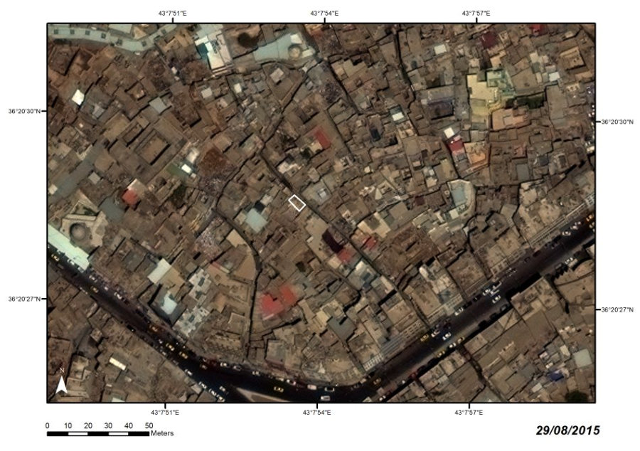
East Mosul, Hayy al-Andalus
LOCATION
Razed (24 June 2015)
STATE
MOSQUE AND TOMB OF AL-KHARRAZI
I74
Satellite images:
WorldView-2 and WorldView-3 © 2013–2016 DigitalGlobe, Inc., distributed by European Space Imaging GmbH/ARCDATA PRAHA, s.r.o.
Ottoman; modern restoration

PERIOD


The
mausoleum
was
dedicated
to
the
Sufi
Shaykh
Ahmad
ibn
ʽ
Isa
al-Kharrazi
(9th
century),
whose
identity
is
a
matter
of
contention.
The
history
of
the
tomb
is
unknown.
The
site
was
reconstructed
a
few
years
before
1966
(a
small
mosque was built adjacent to the tomb), and again shortly before 2006.

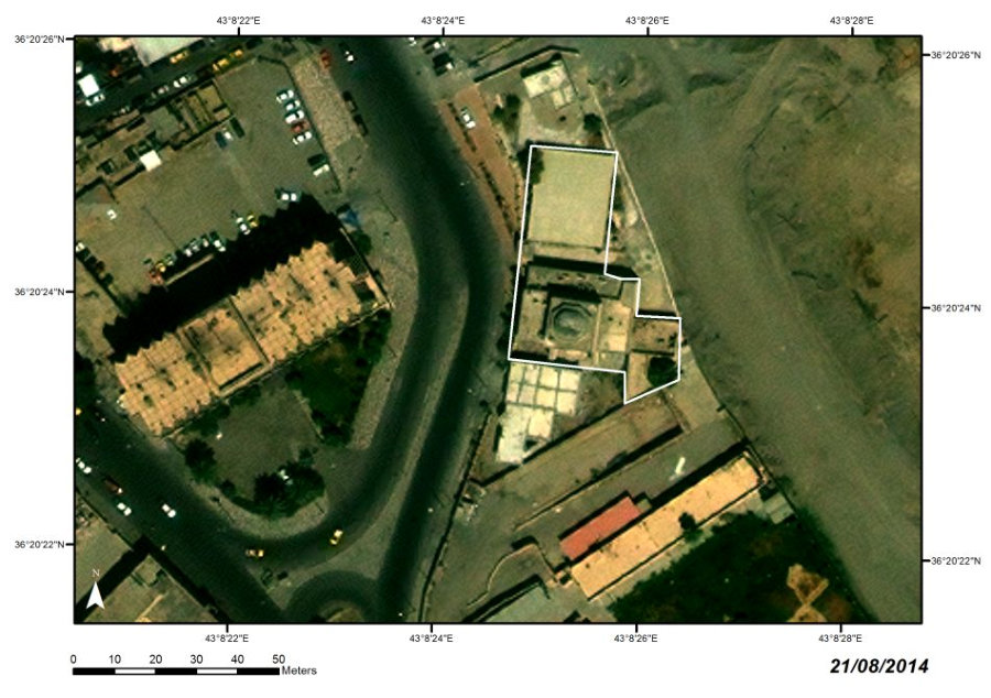
West Mosul, Suq Bab al-Saray
LOCATION
Razed (around 21 June 2014)
STATE
AL-SARAY POLICE STATION
MADRASAT AL-SANA ʼIʽ

P16
Satellite images:
WorldView-2 and WorldView-3 © 2013–2016 DigitalGlobe, Inc., distributed by European Space Imaging GmbH/ARCDATA PRAHA, s.r.o.
Late Ottoman
PERIOD


This
late
Ottoman
administrative
building
was
occupied
by
several
institutions
during
the
course
of
the
last
two
centuries.
It
served
as
a
Christian
school,
a
School
of
Crafts
(Madrasat
al-Sana
ʼ
i
ʽ
),
and
a
police
center.
The
building
had
already
been
damaged by a suicide attack in 2005.